Preparation, I have often said, is rightly two-thirds of any venture.
Amelia Earhart
Where does the AZT start?
Sometimes, just a casual question gets you thinking about what matters most. I leave on Monday for Tucson to start walking the Arizona Trail. On the phone with my dad yesterday as I shared that I’d sent two resupply boxes ahead filled with homemade and dehydrated food. I then added that I’d packed four days of food for my first 50+ miles and that prompted him to he veer away from food to ask, “Where does the trail start?”
When I replied the Coronado National Memorial southeast of Tucson, he immediately wanted to know what the Memorial was memorializing. Um, well, uh…let’s ask Dr. Google!
A beautiful website popped up with a dated video telling the story of Francisco Vázquez de Coronado who led the aptly named Coronado Expedition of 1540. A group of Spanish and Aztec warriors – along with slaves – walked these same trails into what is now the Southwest United States. They were on the hunt for the lost cities of gold. They never found the gold, but they did end up changing everything and everyone in their path (usually by force) which led to cultural collapse followed by cultural fusion.
But wait, there’s more – and this from only two years ago. 7,000+ public comments in opposition made no difference and the 9th Circuit wasn’t stopping them either. So, in a flurry of activity right before Trump lost the election, a piece of his border wall got the green light it needed – and inside a national monument where it was most definitely not needed.
The southern terminus location of the AZT on Mexico’s border was selected specifically due to its natural and wild beauty at the convergence of four geographic regions: the Madrean, Sonoran, Chihuhuan and Southern Rockies/Mogollan. Border Patrol has been monitoring the area successfully using sensors, so building a physical barrier was more about scoring political points than stopping illegal activity. A monstrosity of steel and concrete not only closed a portion of trail and marred the views, but it also bisected this stupendous sky-island terrain, essential habitat for endangered species like the jaguar and ocelot.
The Trail Association made attempts to mitigate damage, but they were rebuffed and it would take a change of administration to put a halt to construction. Still, the trail remained closed due to abandoned materials, unstable soils and open tranches created from dynamite causing safety concerns – until December 31st when the trail was reopened.
Just in time for my feet to walk on it.
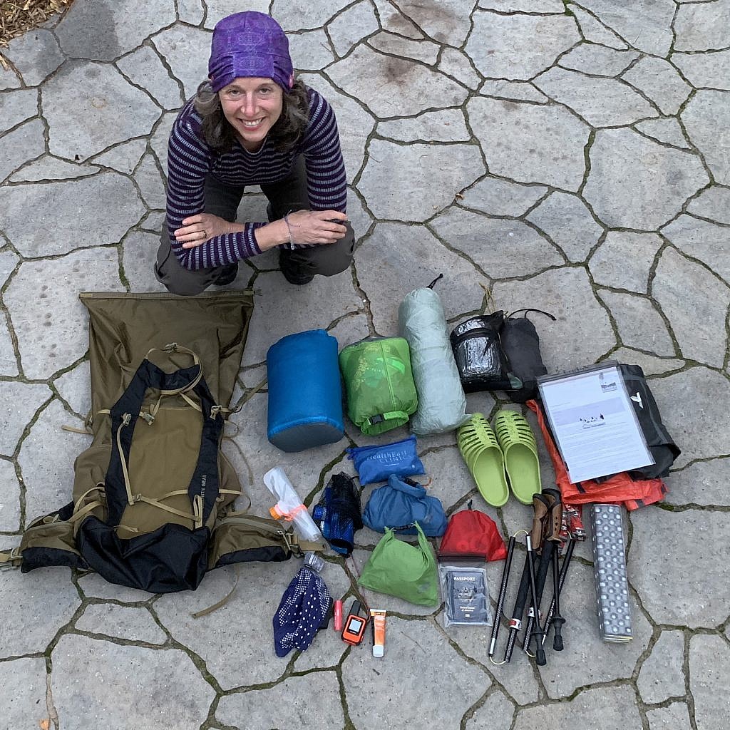
What are you packing?
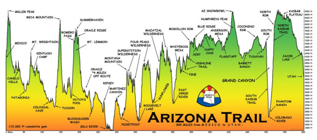
My dad went on to ask about what I’m taking. The curious thing about the Arizona Trail is that it’s not just one stretch of desert, but rather widely varied terrain. It’s rocky and sandy, desert and mountainous, arid and (because March/April are shoulder-season) wet – usually from snow. I chose the Goldilocks moment to hike to avoid scorching heat, but, having written that, I think of hiking Scotland’s Cape Wrath Trail in October which was supposed to be cool and dry. A hiker is never certain the exact weather pattern, but I’ll likely have warm days and cold nights, with ice possible on trail all the way to the North Rim requiring microspikes. I’ll also try something new – and very Scottish – wearing freezer bags between by socks to keep my feet dry.
Cold nights, high-ish altitude and possible snow translates to a warm sleeping system – Big Greenie, my Western Mountaineering Versalite down bag rated for 10 degrees. I use a blow-up mattress Therma-a-Rest Neo Air XLite, but this is the desert we’re talking about where everything wants to poke at you. I’ll add a piece of Tyvek to the mix as a barrier against punctures, especially if I cowgirl camp. Even in the heat of the Sonoran Desert, I’ll be covered head to toe in long pants, long sleeves, sun hat and gloves with many an extra layer to add and take off.
Check out my updated AZT gear list here!
Next to the weather extremes, the biggest concern of all who hike the AZT is water. Water is seasonal and often questionable from tanks, troughs and windmills. It’s imperative I keep a clean filter from all the gunk like silt, sand and “floaties”. A bit of old panty hose over my Sawyer Squeeze should do the trick, plus backflushing the filter religiously. In the event the filter fails, I’ve packed chlorine dioxide pills – mmm, that water is going to taste amazing! (sarcasm)
Also, I’ll have longer carries, sometimes all day and to a “dry camp,” so I’ll pack a 4 1/2 liter capacity. Honestly that’s all I can manage to carry as each liter weighs over 2 pounds, more than my tent! There are trail angels who cache water in metal lockers along the way in metal boxes (a lot like the bear boxes you see in the Sierra) set up by the trail association, but the key is to not be wholly dependent on water sources that might not be there. And, one more thing – I’ll plan to sleep with the filter. Nights likely will get down below freezing and a frozen water filter is a useless water filter!
And to carry all this stuff? I’ll use my bigger 60 liter backpack, the Granite Gear Crown 2 (made in Minnesota!)
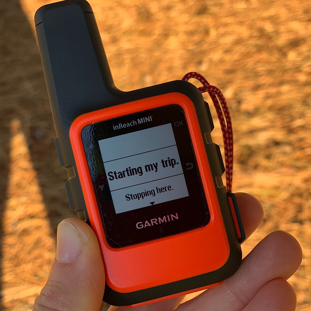
How will you keep in touch?
After the hike, I’ve been invited to present talks on my Te Araroa and Pacific Crest Trail thru-hikes in San Francisco where my dad lives. He wanted to make sure we could communicate but somehow thought I might be more like the Coronado Expedition, without contact for weeks on end.
The trail is remote, thought I’ll be hitting towns and roads every few days with a chance to rest and resupply. When out of cell range, I’ll use my Garmin inReach to keep Richard abreast of my whereabouts and feel confident I have SOS capability (which I hope to never use again.) I’ve packed extra beta-blockers should the SVT return, plus lots of electrolytes and good food. I’ll cold soak again (which means no cooking) We’ll see how long that lasts with chilly mornings, though I have spent the last few weeks detoxing from coffee. The headaches I get from withdrawal are awful, but it’s worth it to keep from having to carry a stove!
Because I write every day and take thousands of pictures, my phone is my lifeline. I killed the camera feature in Scotland from all that rain. I now have a new phone and want to ensure it works the entire way. I carry a RAV portable battery that should top up both my phone and GPS for six days or so. Still, the idea that I could run out of power is nerve-wracking, so I created this checklist to maximize power saving.
Battery (and life) Saving Steps for backpacking with an iPhone
- Turn off notifications – Settings > Notifications
- Adjust Screen brightness – Settings > Display and Brightness
- Activate low power mode Settings > Battery
- Turn off location services – Settings > Privacy > Location Services
- Turn off background refresh app – Settings > General > Background Refresh
- Switch to airplane mode
- Turn off wifi, Bluetooth and airdrop – Settings
- Turn off Siri suggestions – Settings > Siri & Search
- Turn off automatic app updates – Settings > App Store
- Remove motion effects – Settings > Wallpaper
- Manage vibrations – Settings > Sounds
- Tame iCloud – Settings > Photos